


A flash flood watch was put into effect for the burn areas in Northern Colorado for much of Thursday, July 28 due to heavy rainfall from the previous night. The Larimer County Sheriff’s Office issued Flash Flood Warning on Wednesday, July 27 at 9 pm.
The warning was issued through the National Weather Service and included the East Troublesome, Cameron Peak, Williams Fork, and Calwood burn scars while also warning that more torrential rainfall could potentially trigger additional flash flooding along with debris flows.
This is the Larimer County Sheriff’s Office with an emergency message. The National Weather Service issued a Flash Flood Warning for many areas of the Cameron Peak burn scar. This message is for those in the Glen Haven, Storm Mountain, and Retreat areas. HEAVY RAINFALL WILL CAUSE EXTENSIVE AND SEVERE FLOODING OF CREEKS, STREAMS, ROADS AND CULVERTS IN THE AFFECTED PART OF THE CAMERON PEAK BURN AREA. ROCKSLIDES OR DEBRIS FLOWS CAN ALSO BE EXPECTED ACROSS ROADS IN THE WARNING AREA. Please be prepared to move to higher ground if heavy rainfall produces the anticipated flash flooding.
Meteorologist Greg Hanson with the National Weather Service said that the flash flood watches were mostly focused on the I-25 corridor and west, but the main concern was still the Cameron Peak burn area. He added that continued heavy rainfall can also remain a concern and create a high potential for flooding in rural areas such as Morgan and Washington County where the flatter areas take longer for the water to recede. Greg also added it’s best to stay as prepared as possible during times when the atmosphere is unstable.
“We have vacationers who might not really be familiar with the burn area and if they’re in an area that hasn’t really been burned through upstream, there’s still some of that area that hasn’t recovered from the fire and so people just need to be aware of what the threat is, keep an eye out and be ready to move to higher ground if they’re in an area that’s flood-prone. This isn’t anything to mess around with,” Greg said. “We’ve lost the forest canopy, all the root structure that holds the ground in place, so when the rain hits the ground, it hits hard, and it runs off fast and takes a lot more stuff with it than it normally would. So, it’s a different environment than what people are used to; the impacts are greater, things happen a lot more quickly, and so it’s something that people need to pay attention to.”
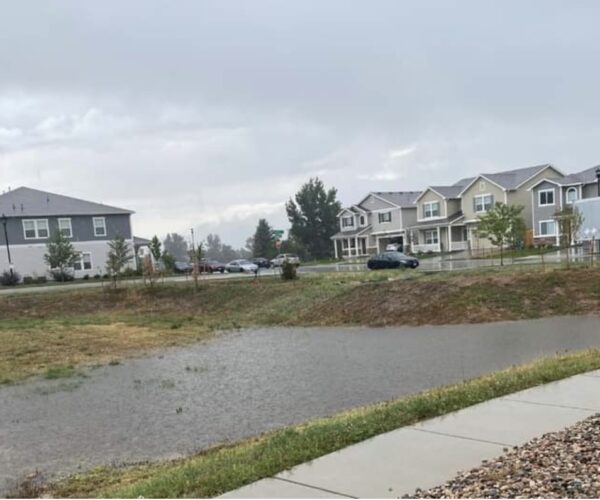
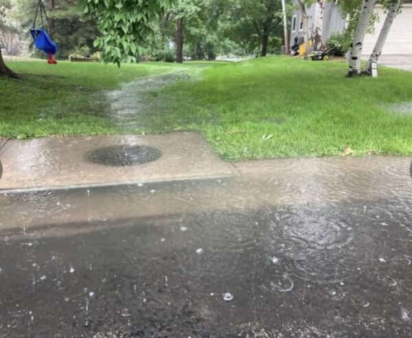
According to the City of Fort Collins Utilities, on Thursday, July 28 there were crews who had successfully localized the flooding near Shields and Mulberry Street and there was some additional flooding on the east side of town on Mulberry Street. Ditches at that time were currently very full but the breaks in the storms were keeping them from overflowing. The City also offered the following safety reminders:
- Don’t go near drainage ponds
- Don’t play or recreate near waterways
- Keep updated on weather forecasts
- Don’t drive through floodwater
CSU Climatologist Russ Schumacher said the rainfall that most recently took place over Wednesday night and into Thursday morning was unusual for the area, only adding to the concern of unpredictable weather seen so far this summer.
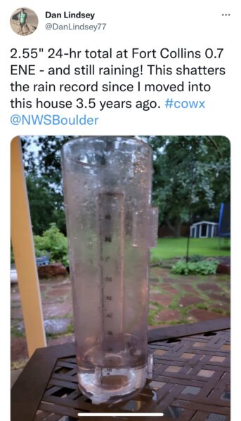
“It’s pretty unusual to get heavy rain from 1 to 3 in the morning and then again from 5 to 7 in the morning from strong storms, that’s not the usual situation we get here. It was pretty heavy rain amounts with over 2 inches over most of the east side of Fort Collins and Wellington with over 2 inches and then a whole lot of hail in Estes Park,” said Russ. “As we’ve seen with the summer so far it doesn’t take that much rain to cause problems on the burn scar, if you get even just a quarter inch of rain in 15 or 20 minutes and it hits in the right spots in a hurry then the flooding can happen really quickly as we saw with the unfortunate incident a couple of weeks ago.”
The incident Russ was referring to took place on July 15, when two people within Larimer County died from flash flooding in the Glen Haven and Crystal Mountain areas west of Fort Collins according to a news release issued through the Larimer County Sheriff’s office. The report indicated that a camping trailer had been washed away in the middle to upper Buckhorn area. The sheriff’s office received reports that the camping trailer had been occupied by an adult woman and a juvenile female and after search efforts were made, bodies were found, according to the release.
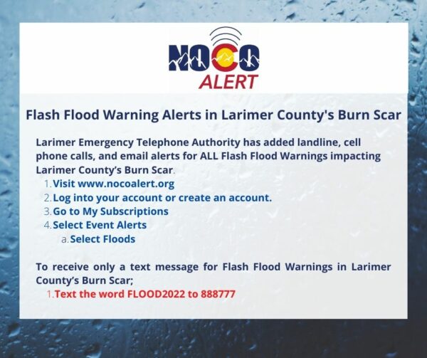
Ricardo Perez, Communications Coordinator for Larimer County Emergency Management department said Larimer Emergency Telephone Authority (LETA) has added landlines, cell phone calls, and email alerts for all flash flood warnings impacting Larimer County’s burn scar, making it easier to receive flash flood warnings multiple ways:
- Sign up or update your account at www.nocoalert.org to include weather alerts.
- Text FLOOD2022 to 888777 to receive flood warnings via text message!
- Download the Reachwell App and select NOCOALERT to receive flood warnings via app push.
“It’s really important for the public to have different means of receiving information and staying aware of the current weather. Another good thing is also if people want to look into a weather radio that they can have in their homes,” said Ricardo. “We have some available here in the office of emergency management if people have a hard time looking for these. They’re typically about $10 at the grocery stores, but we do have a number of them available for the community for those folks who kind of have a hard time getting one of the alert radios. The main thing is staying as alert as possible and knowing that whenever there’s an adverse weather situation to be vigilant of the area and your surroundings, as well.
You can also contact LETA by email at [email protected] or online at leta911.org/contact-us.
For those in Weld County, you can go to Emergency alerts – www.weld911alert.com.
Support Northern Colorado Journalism
Show your support for North Forty News by helping us produce more content. It's a kind and simple gesture that will help us continue to bring more content to you.
BONUS - Donors get a link in their receipt to sign up for our once-per-week instant text messaging alert. Get your e-copy of North Forty News the moment it is released!
Click to Donate