By Reghan Cloudman
Public Affairs Specialist, Forest Service – Arapaho and Roosevelt National Forests and Pawnee National Grassland
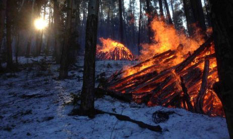
As we get started in the new year, firefighters are evaluating conditions in our many pile burning areas. If we have retained snow over the last few weeks or we receive new, adequate snow conditions, we will continue our pile burning operations over the coming weeks. More than 6,600 piles have been burned on the Canyon Lakes Ranger District this winter.
Pile burning could occur in one or more of these locations:
- Red Feather 3 (hand piles located north/northeast of Red Feather Lakes)
- Red Feather 4 (hand piles located in the Red Feather Lakes area south and east of Molly Lake Trailhead)
- Glen Haven 1 (hand piles located north of Glen Haven near North Fork Trailhead)
- Thompson River 4 (hand piles located six miles east of Estes Park)
- Deadhorse-Pratt Creek (machine piles located north of County Road 80C on Forest Service Road 182, adjacent to Deadhorse Mountain)
- Magic Sky 2 and 3 (hand piles east of Red Feather Lakes, north of County Road 74E and near Magic Sky Ranch)
These piles are only ignited under certain conditions, including favorable smoke dispersal and adequate snow cover. The areas are monitored after burning is completed. When and where burning occurs depends on the conditions listed above.
Fire spread from slash pile footprints occurs and can often be anticipated within treatment units. Hand piles can hold heat for several days, while machine piles may hold heat for several weeks. Treatment areas typically lose snow more quickly than surrounding untreated areas as a result of increased sun exposure and wind scour from thinned trees. Fire managers track weather and site conditions for control, primarily focusing on treatment unit perimeters. Fire staff monitor burned areas and unit perimeters are of greatest concern. If snow is lost or piles continue to hold heat within these areas, fire crews will extinguish them. Smoke and flames are visible while piles burn down. Unlike the Larimer County issued smoke permits, the U.S. Forest Service obtains smoke permits from the State of Colorado. State issued permits do not require extinguishment of piles by nightfall, so it is normal to see piles still burning into the night.
For information on where pile burning is occurring on the Arapaho and Roosevelt National Forests, visit http://inciweb.nwcg.gov/incident/4648/. Prescribed fire smoke may affect your health. For more information see https://www.colorado.gov/pacific/cdphe/wood-smoke-and-health.
Support Northern Colorado Journalism
Show your support for North Forty News by helping us produce more content. It's a kind and simple gesture that will help us continue to bring more content to you.
BONUS - Donors get a link in their receipt to sign up for our once-per-week instant text messaging alert. Get your e-copy of North Forty News the moment it is released!
Click to Donate
