

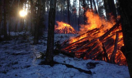
 Fort Collins, Colo. – Canyon Lake Ranger District firefighters are monitoring conditions in the Roosevelt National Forest to burn slash piles left from multiple fuels reduction and hazardous tree removal projects, as well as conduct broadcast burns, this winter.
Appropriate conditions must be met before burning can take place. Fire managers are carefully monitoring these conditions, including a favorable weather forecast (temperature, wind, precipitation, etc.), fuel moisture, smoke dispersal and staffing. Weather is monitored throughout the burn and burning will be halted if conditions fall outside of the required conditions. Public and firefighter safety is always the number one priority in burning operations.
Area with slash piles ready for burning are:
- Crown Point (located south of Rustic on Forest Road 139 near Salt Cabin Park): 19 machine piles
- Red Feather North (located 4 miles north of Red Feather Lakes): 50 hand piles
- Magic Sky (located 4 miles southeast of Red Feather Lakes): 22 hand piles
- Pearl Cache (located 7 miles west of Red Feather Lakes): 5 machine piles
- Stringtown West (located 12 miles west of Fort Collins): 100 hand piles
Broadcast burns that could occur this winter/spring include:
- Bighorn Sheep Prescribed Burn: Located on the north side of the Poudre Canyon near the Roaring Creek Trailhead, approximately eight miles west of Rustic.
- The project is 636 acres, with 85% of these acres on National Forest System lands and the other 15% on Colorado Parks and Wildlife lands.
- The objective of the burn is to improve wildlife habitat and reduce hazardous fuels.
- This winter, burning would take place when south facing slopes within the project area has minimal to no snow and north facing slopes have snow cover to contain the burn.
- Detailed information: inciweb.nwcg.gov/incident/5676/
- Red Feather Prescribed Burn: Located north of Red Feather Lakes; east of the Crystal Lakes Subdivision.
- Last spring 1,513 acres of the total 4,348-acre project was successfully burned.
- The two burn units remaining are 707 acres and 2,027 acres.
- Detailed information: inciweb.nwcg.gov/incident/5027/
- Pingree Hill Prescribed Burn: Located north of Highway 14, east of Rustic.
- Nearly 600 acres of this 2,027 acre burn took place between 2014 and 2017.
- Detailed information: inciweb.nwcg.gov/incident/4727/
In ideal conditions, as many as 500 acres could be burned in one day on these broadcast burns. Work has already taken place within these project areas to help ensure the burn stays within its identified perimeter. The burns will be staffed appropriately with up to 30 firefighters, often including local agencies and volunteer fire departments. Staffing requirements vary by project.
To check the latest updates on when burning could occur, check our recorded incident information line at 970-498-1030 or follow us on Twitter @usfsclrd. To get added to the email notification list, send an email to [email protected] and identify which prescribed burn you are interested in. Information is posted online at inciweb.nwcg.gov/incident/4648/ for pile burning. Prescribed fire smoke may affect your health. For more information see colorado.gov/pacific/cdphe/wood-smoke-and-health.