R. Gary Raham
graham@northfortynews.com
In 1869, Alfred Augustus Edwards and other men originally from Mercer County, Pennsylvania, decided to farm near the Poudre River. They founded a short-lived Mercer Colony on land now owned by Grandview Cemetery in Fort Collins. Union Colony, which would eventually become Greeley, fared better. They dug a ditch just upstream of Laporte, Colorado, to divert water for agriculture. Larimer County Land Improvement Company founded the Agricultural Colony established near the decommissioned Fort Collins. Friction erupted between the two colonies when the Fort Collins group began diverting water upstream from Union Colony. Union Colony demanded that the Agricultural Colony respect their earlier rights to the water.
The dispute ultimately codified water rights in Colorado’s Doctrine of Prior Appropriation: Whoever uses water first and puts it to “beneficial use” gets first dibs. Poudre River water was already “over appropriated” during the 1870s. (See https://publiclands.colostate.edu/digital_projects/dp/poudre-river/)
Coloradans have been arguing over water, and trying to manage it, for at least 150 years. Where do we stand today in managing Poudre River water? This third article in a series of four in the North Forty News will attempt to address this question.
Some river facts
- Rivers are renewable resources. Moisture evaporates, rises into the sky as clouds, and eventually falls to Earth as rain or snow that cascades as rivers from high to low ground. The amount of water that ends up flowing downhill varies considerably—especially in the west—over both short- and long-term cycles. All the climate models projected by NOAA (National Oceanic and Atmospheric Administration) project a warmer and drier climate for Colorado’s Front Range. By 2050, Denver will have a climate similar to Pueblo (at the low end of projected warming) or Albuquerque (at the high end) (https://www.climate.gov/print/325954).
- Flowing water carves the land into picturesque forms, carries rock and soil downhill, and provides habitat for many creatures that make their living in or near water. The rate that water flows determines oxygen content in the water, the amount of dissolved material it contains, and the nature of the kinds of living communities that form in or near rivers.
- In general, river water is purest near the source and less so as it is used and reused downstream. It costs more to process drinking water farther down the hill.
- Approximately 86% of Colorado’s water runs west off the Rockies in the Colorado, Delores, San Juan, San Miguel, Gunnison, Yampa, White and Green Rivers. Approximately 14% runs east into the Rio Grande, North Platte, South Platte, Poudre and Arkansas Rivers. More than half of the 5 million plus humans in Colorado reside east of the Rockies.
- In Colorado, we sit at the source of the major river systems listed above. We get to use, store and manage river flows and diversions first (with some limitations imposed by agreements like the 1922 Colorado River Compact) before passing that water downstream. Water stored in reservoirs is measured in acre-feet: an acre’s worth of water one foot deep. That equals 325,851 gallons—about enough to serve 3,258 people for one day.
- The Poudre currently flows through Fort Collins at approximately 60% of the rate of flow it possessed when Alfred Edwards started thinking about ditches.
How many ways can we use—or abuse—Poudre River water?
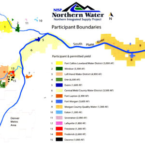
 NISP is an acronym for Northern Integrated Supply Project. The U.S. Army Corps of Engineers began the Environmental Impact Statement (EIS) for this water project in 2004 and issued a draft for public comment in 2008. The plan is to build two reservoirs (Glade and Galeton) that would provide 15 Northern Front Range water partners (see map) with 40,000 acre-feet of additional water supplies. Glade Reservoir northwest of Fort Collins near the intersection of US 287 and Colorado Highway 14 would be slightly bigger than Horsetooth Reservoir and hold 170,000 acre-feet of water. Galeton would be located east of Ault and northeast of Greeley and store 45,600 acre-feet at full capacity. Northern Water estimates the cost will be about a billion dollars with the first water stored in Glade to serve an estimated half a million residents in 2025. (See http://www.northernwater.org/sf/WaterProjects/NISP for details.)
- In their 2015 comments in the Supplemental Draft Environmental Impact Statement (SDEIS), the City of Fort Collins proposed a modified version of NISP that would divert water at different locations to help prevent reduced river flow through the city.
- Aaron Million wants to pipe water from the Green River below Flaming Gorge to Northern Colorado through a pipeline that would parallel I-80 across Wyoming and then turn south into Colorado. Million’s pipeline idea started out as a Ph.D. research project at Colorado State University. In 2012, his project ran into a snag when the Federal Energy Commission (FERC) denied his application for the project, but Million said the Commission just needed more information, which he can now supply. Million describes himself as an environmentalist. He took a couple of years off from the project to refocus “and rope wild burros and kayak,” but the project could now be supplying water within 18 to 20 months. Million said the 55,000 acre-feet diverted from the Colorado represents only half of one percent of its flow and could add water flow to the Poudre, perhaps by entering the system at its North Fork, and contributing to Halligan and Seaman Reservoirs.
- The City of Thornton is beginning to build a pipeline to use its water rights to the Poudre acquired some decades ago. (See an article in the April issue of the North Forty News https://northfortynews.com/the-thornton-pipeline-project-how-the-city-of-thornton-plans-to-pull-water-from-the-poudre-river/)
- Realtors often buy farmland, along with its water rights, for development, a practice referred to as “buy and dry,” because agriculture can no longer use that water for farming. Another option is to lease that water and keep farmers on the land. Kerri Rollins, Larimer County Open Lands Program Manager, discussed a successful example of this at the 2018 Poudre River Forum, but the process requires considerable negotiation between landowners and municipalities—and involves, in some cases, changing laws and/or farming practices.
- Gary Wockner, director of Save the Poudre, says conservation is “faster, easier, and cheaper.” Conserve First might be his mantra, and then talk about engineering solutions to water problems later. Wockner, a politically active ecologist, thinks utility planners are “intensely arrogant” to expect the people whom they serve to be able to water lawns even in times of drought. He cites California’s “cash for grass” programs that pay people to replace grass with more appropriate xeriscaping. Save the Poudre formed in opposition to NISP. Wockner considers Million’s Flaming Gorge pipeline “the most far-fetched idea he’s ever heard of.” Yet, when asked how he would manage the Poudre if given total control, he was at a loss for an immediate answer.
Managing water fuels strong emotions in people. It should. It is the key to surviving in this beautiful, though arid, land. John Fielder, who has been providing the striking images of the Poudre River for this series, said, “If I cannot convince enough people to protect the reasons why most of us live in Colorado, not only will I no longer be able to photograph for my living, I will have been complicit in denying my grandkids the wonderful outdoor opportunities that have been afforded to me. I cannot live with that.”
The next article in this series explores the resources available to learn more about water issues in Northern Colorado and what we can do as citizens to live responsibly and make sound decisions about the liquid now more precious than the gold sometimes found within it.
Support Northern Colorado Journalism
Show your support for North Forty News by helping us produce more content. It's a kind and simple gesture that will help us continue to bring more content to you.
BONUS - Donors get a link in their receipt to sign up for our once-per-week instant text messaging alert. Get your e-copy of North Forty News the moment it is released!
Click to Donate
The statement that “The City of Thornton is beginning to build a pipeline” is incorrect. First, the Thornton Northern Project has state Water Court approval for a 3-phase, 3-pipeline project. The second and most obvious fact is that the City of Thornton cannot “build” anything, unless the proposal (called a 1041 application) gets the approval of the Larimer County Planning Commission and Board of County Commissioners, who are not required to allow the project, if the impacts are detrimental to the residents of Larimer County. Hopefully the NFN will cover the 5/16 and 7/9 hearings, so your readers will understand the high level of opposition to the destructive plan for delivering water to Thornton bluegrass.