

by Blaine Howerton | NorthFortyNews.com
FORT COLLINS, CO — A Northern Colorado family of four can leave a College Avenue parking spot at 6:30 a.m. on a Saturday in June and reach the Bear Lake trailhead inside Rocky Mountain National Park by 9 a.m., according to drive-time data from the Colorado Department of Transportation and route notes shared by Poudre School District parents who run the trip three or four times a season.
The route is the closest national park day trip for Fort Collins, Loveland, and Windsor families, and the cheapest by a wide margin. From the Mulberry Pool roundabout in Fort Collins, the Beaver Meadows entrance is roughly 47 miles west on US-34 through the Big Thompson Canyon, an hour and ten minutes when summer weekend traffic cooperates and closer to two hours when it does not. The road is paved every mile, but the cell coverage is not, and Trail Ridge Road, the Wild Basin spur, and the back side of Lumpy Ridge each include confirmed no-signal pockets that catch first-time NOCO visitors off guard each season.
Key takeaways
- Rocky Mountain National Park’s Beaver Meadows entrance is 47 miles from Fort Collins on US-34, roughly an hour and ten minutes without summer weekend traffic.
- The Bear Lake Road timed-entry reservation runs Memorial Day through mid-October in 2026, 5 a.m. to 6 p.m., booked at recreation.gov 30 days out.
- Wild Basin, near Allenspark, sits 25 miles south of the Estes Park entrance and runs on a separate gravel-road logistics window — no timed entry, gates close at sunset.
- Lumpy Ridge, 5 miles north of Estes Park off Devils Gulch Road, is the closest hiking-only trailhead to NOCO and is the easiest first park trip with kids ages 4 to 8.
- Trail Ridge Road climbs to 12,183 feet at Gore Range Overlook with three confirmed no-signal stretches; download offline Google Maps for the Estes Park region before leaving the Stanley Hotel parking lot.
What the day-trip geography actually looks like
There is no shortage of Rocky Mountain National Park guides written for visitors flying into Denver. This is not one of those. From Fort Collins, the geometry is different: US-287 south to Loveland, then US-34 west through the Big Thompson Canyon into Estes Park, then either the Beaver Meadows or Fall River entrance into the park itself.
“Most of our spring and early-summer visitation is in-state, and a good share of that is the I-25 corridor from Fort Collins south to Denver,” said Kyle Patterson, public affairs officer for Rocky Mountain National Park, in a phone interview earlier this month. “If you are coming from Fort Collins, your biggest variable is the Big Thompson Canyon backup at the Drake hairpin between 8 a.m. and 10 a.m. on Saturdays, not the park entrance line itself.”
The three-day trips in this playbook are not the only routes into the park worth taking. The Grand Lake side, the Old Fall River Road climb in late summer, and the longer Cameron Peak burn-scar approaches through Glen Haven all deserve their own pieces. They are, however, the three-day trips NOCO parents ask about most.

Stunning view of the Rocky Mountains during a warm sunset in Telluride, Colorado.
Photo: Joetography via Pexels
Bear Lake: the timed-entry weekend default
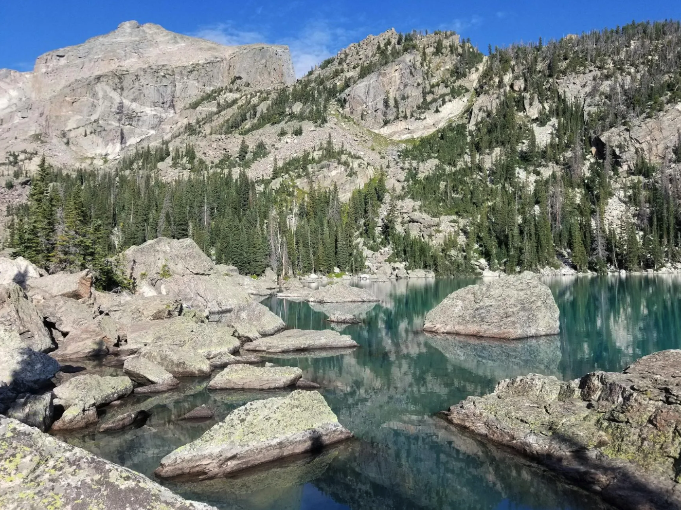
ESTES PARK, CO — Bear Lake is the Fort Collins family default for a reason. The trailhead sits at 9,475 feet, the loop around the lake is 0.8 miles and stroller-passable for the first two-thirds, and the views of Hallett Peak and Longs Peak are the photographs that ride home on every family’s camera roll.
The catch is the Bear Lake Road timed-entry reservation. The park’s pilot reservation system, renewed by the National Park Service for 2026, requires a separate vehicle permit for the Bear Lake Road corridor between 5 a.m. and 6 p.m. from late May through mid-October, on top of the standard park-entry pass. The permits are released at recreation.gov in two windows: a 30-day-out monthly block and a 7 p.m. day-before remainder release. Fort Collins parents who run the trip a half-dozen times a summer have learned to set a recreation.gov alert for both windows.
A practical note for first-timers. The Bear Lake parking lot fills by 8 a.m. on summer Saturdays. The Park-and-Ride shuttle from the Glacier Basin lot runs every 10 to 15 minutes, is free with park admission, and is honestly the calmer way to arrive with kids under six. The shuttle stops at Bierstadt Lake, Glacier Gorge, and Bear Lake itself; the round-trip from Glacier Basin to Bear Lake and back runs about 45 minutes, including hike time at the lake.
Wild Basin: the quieter gravel-road option
ALLENSPARK, CO — Wild Basin is the trip Fort Collins families take when they want the park without the Bear Lake crowds. The trailhead is 25 miles south of the Estes Park entrance off CO-7, then 2.2 miles up a graded gravel road. The drive from Fort Collins runs 65 miles and roughly an hour and forty-five minutes via US-287 south to Lyons, then CO-7 north past Allenspark to the Wild Basin spur.
The trail to Copeland Falls is half a mile from the trailhead and the easiest waterfall in the park to reach with a 4-year-old. Calypso Cascades is 1.8 miles farther up. Ouzel Falls, at 2.7 miles and 950 feet of climb, is the turnaround point that most Fort Collins parents set for kids ages 7 and up.
A few hard-earned notes from three Wild Basin runs with my own family between 2023 and 2025. The Wild Basin gate closes at sunset, which in late June means a 9 p.m. cutoff and in early September means a 7:15 p.m. cutoff. The ranger station at the trailhead has the only flush restroom on the spur; the Sandbeach Lake trailhead a mile back has a vault toilet but no water. There is no cell service past the gravel turnoff from CO-7, so the offline map download has to happen back in Lyons or Estes Park.
Lumpy Ridge: the first-park-trip option for small kids
ESTES PARK, CO — Lumpy Ridge is the trailhead most NOCO parents underuse. It sits 5 miles north of downtown Estes Park off Devils Gulch Road, requires no timed-entry reservation, and has a parking lot that holds 60 vehicles and clears out by 11 a.m. on most summer Saturdays as climbers head up to the granite domes.
The Gem Lake trail is the family pick. It runs 1.7 miles each way to a high alpine pond tucked between rock outcrops, with roughly 1,000 feet of climb spread across switchbacks short enough for a 5-year-old. The Twin Owls outcrop a quarter-mile in is a worthwhile photo stop and a fair turnaround if the wind is coming through hard. The Black Canyon trail from the same parking lot heads northwest into the McGraw Ranch corridor and is the longer option for parents whose kids will hike four miles in a stretch.
A practical note. The Lumpy Ridge lot has no water and no trash service; pack out everything including diapers. The Stanley Hotel sits at the elbow of the MacGregor Avenue turn off US-34 Business and is a worthwhile coffee stop on the way in.
Staying online across the USA
Rocky Mountain National Park covers parts of Colorado where Verizon LTE works perfectly and parts where the realistic ceiling is two-bar 3G or no signal at all. For Fort Collins parents keeping teens reachable on a day trip, or for the relatives flying into DEN to ride along, knowing which stretch is which up front saves a real argument at the trailhead.
What works where between Fort Collins and Bear Lake
| Route segment | Strongest carrier | Signal quality | Notes |
|---|---|---|---|
| Fort Collins → Loveland (US-287) | Verizon, AT&T, T-Mobile US | Full 5G | All three carriers reliable; T-Mobile US slightly faster in speed tests |
| US-34 Loveland → Drake | Verizon, AT&T | 4G/5G mix | Coverage solid; expect drops in the Big Thompson Canyon narrows |
| US-34 Drake → Estes Park | Verizon | 3G/4G | AT&T patchy past the Glen Haven turnoff; T-Mobile US weakest |
| Estes Park → Bear Lake (Bear Lake Rd) | Verizon | 3G/no signal | Cuts out past Sprague Lake; nothing at Bear Lake itself |
| Trail Ridge Road (Rainbow Curve → Alpine Visitor Center) | Verizon | No signal | Three confirmed dead pockets above 11,500 feet |
| Wild Basin spur (past CO-7 gate) | None | No signal | Full dead zone the entire 2.2-mile gravel road |
The Trail Ridge Road stretch is the one parents underestimate. Between Rainbow Curve and the Alpine Visitor Center the road climbs above 11,500 feet for 11 miles, and the nearest cell tower is 20 miles east in Estes Park. Verizon holds longest of the three U.S. carriers on the climb out of Estes Park, AT&T is hit-or-miss past Many Parks Curve, and T-Mobile US drops first at the Beaver Meadows entrance gate. Download offline Google Maps for the Estes Park region before leaving the Stanley Hotel parking lot; the visitor-center Wi-Fi at the Beaver Meadows ranger station is functional for trip-plan check-ins but useless once the road climbs.
For grandparents or family flying into DEN from outside the country to ride along on these day trips, the carrier reality is the same. Verizon, AT&T and T-Mobile US are the three networks any visitor connects through, whether on a roaming plan or a travel eSIM. Before flying in, grab a mobile data plan for travellers with coverage on Verizon — I used it on a 2024 Wild Basin day with my father visiting from Lahore, and it routed through Verizon between Lyons and Allenspark, which mattered on the CO-7 stretch because his default carrier roaming dropped completely past the Estes Park town limit. The eSIM kept him reachable on his WhatsApp groups at home and on our family thread on the drive back through Big Thompson Canyon. The coverage table above is the real takeaway here, mentioned once and never again.
What to pack that the print guides skip
Three small items earn their pack space on every one of these three day trips. A paper map of Rocky Mountain National Park from the Beaver Meadows visitor center, free with park admission, for the moments above 11,000 feet when the phone is a brick. A USB-C car charger that actually delivers 30 watts, because the climb to the Alpine Visitor Center drains a phone battery in two hours of GPS use. And an insulated 24-ounce water bottle for each hiker; the elevation between Fort Collins at 5,003 feet and the Alpine Visitor Center at 11,796 feet is a 6,800-foot gain in 70 miles, and dehydration headaches show up in kids before they show up in adults.
FAQ
How far is Rocky Mountain National Park from Fort Collins? The Beaver Meadows entrance is 47 miles west of Fort Collins on US-34 through the Big Thompson Canyon, roughly an hour and ten minutes without summer weekend traffic. Add 30 to 50 minutes for backups at the Drake hairpin between 8 a.m. and 10 a.m. on Saturdays in June and July.
When does the Bear Lake Road timed-entry reservation start in 2026? The Bear Lake Road timed-entry permit runs Memorial Day weekend through mid-October in 2026, 5 a.m. to 6 p.m. daily. Permits release at recreation.gov in two windows: a 30-days-out monthly block at 8 a.m. mountain time and a 7 p.m. day-before remainder release.
Is Wild Basin doable in a single day from Fort Collins? Yes. The drive is 65 miles via US-287 south to Lyons and CO-7 north to the Wild Basin spur, about an hour and forty-five minutes each way. Plan for Copeland Falls with kids under six, Calypso Cascades for ages six through ten, and Ouzel Falls for ten and up. The gate closes at sunset.
Where does cell service drop on Trail Ridge Road? The three confirmed dead pockets are between Rainbow Curve and Forest Canyon Overlook, between Lava Cliffs and the Alpine Visitor Center, and the full descent into Milner Pass. Verizon holds longest, AT&T drops past Many Parks Curve, and T-Mobile US drops at the Beaver Meadows entrance gate. Download offline maps in Estes Park before climbing.
What should Fort Collins families pack for a Rocky Mountain day trip? A paper park map from the visitor center, a 30-watt USB-C car charger, an insulated 24-ounce water bottle per hiker, layered clothing for a 30-degree temperature swing between Estes Park and the Alpine Visitor Center, sunscreen rated SPF 50 for elevation, and snacks dense enough to skip the Bear Lake snack-bar line.
A closing note for the season
The 47-mile geometry between Fort Collins and Beaver Meadows is the easiest piece of Front Range driving most NOCO parents take for granted. The playbook above is for the families making the trip for the first time, and for the ones who have been making it long enough to forget what they wish they had known on the first run. Rocky Mountain rewards the families who plan three weeks ahead more than the ones who plan three months.